Sale on canvas prints! Use code ABCXYZ at checkout for a special discount!

This entry deals with some lesser known areas in the Southwest that provide fantastic photography opportunities, but on a smaller more intimate scale. Two are a BLM (Bureau of Land Management) controlled area and the others are routes or areas well worth taking the time to experience.
First up is the "San Juan Skyway". Jump over to TripAdvisor and look for San Juan Skyway attraction in southwest Colorado and my review under Justjeffaz for the complete route or "google it" and the State of Colorado Tourist Site will get you the particulars. It, (as well as Northern New Mexico's Road from Santa Fe to Taos), climbs through river valleys, ancient pueblo and Anasazi sites, old mining and railroad towns, and high mountain passes. A loop route takes you from Mesa Verde National Park to Durango, north to Silverton Mining/tourist town over Red Mountain Pass to Ouray, west at Ridgway to Telluride and back south through Dolores and Cortez. Consistently voted one of the top ten drives in the country. Plan carefully as many festivals are held in Durango and Telluride and accommodations may be hard to find and are pricey. For the Budget traveler plan to stay in Cortez or go north of Ridgeway to Montrose. Limited accommodations in Ridgway, Silverton, and Ouray and fairly expensive. But hey where else can you stay in over 100 year old structures with rich western tradition.....
Bisti/De-Na-Zin Wilderness (aka Bisti Badlands for short) is a BLM controlled area 35 miles south of Farmington on NM 371. The eastern end can be accessed from US 551 south of Bloomfield. Here is the official BLM site with directions to the two main areas worth exploring.
Bisti/De-Na-zin Info
Detailed maps are available on-line of each area indicating main outcrops but sometimes just wandering around gleans the best angles and oddities, such as hoodoos, fractured rocks, "cracked eggs" and other delights.
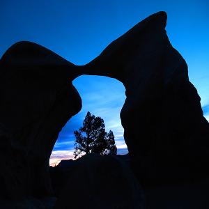
Devil's Garden (in Grand Staircase-Escalante National Monument) is a Natural conservation area south of Escalante, Utah on Hole in the Rock Road (which dead ends at Lake Powell). Home to Metate and Mano Arches (small arches but very photogenic) and several Hoodoos, cap rocks etc. This area of Grand-Staircase boasts many slot canyons in the wash to the east that drains to the south and Lake Powell. Peck-a-boo and Zebra Slot canyons are two of the more famous. While I am discussing the Grand Staircase-escalante area, Utah 12 (a designated Scenic By-way) transverses the northern boundary of the Monument. Starting at Red Rock State Park, going east past the Bryce Canyon turnoff it passes through the town of Escalante, past Calf Creek Falls (a popular day hike), on to Boulder, Utah and then to the turnoff into Capital Reef National Park. A truly great drive with many interesting side trips. Take a short detour down Cottonwood Wash Road from Cannonville takes you to Kodachrome Basin State Park and then on to Grosvenor Arch. Cottonwood Wash Road can be taken all the way to US 89 (20 miles west of Page) but was closed in the fall of 2015 for repairs by the county. Check at any BLM office in Big Water or Escalante for latest updates.
Fantasy Canyon south of Vernal Utah in BLM controlled oil fields is a small outcrop of weathered oddities. Think the special effects on the original Star Trek when they were on a new planet. It is difficult to describe how to get to as the roads crisscross between the oil wells. Once you find the correct turnoff the route is clearly marked. Take Route 45 south of Vernal. At 26 miles there is a turnoff (west) onto 3750 (Glen Bench Road), drive 12.6 miles. There will be a cross road (3310) at the water treatment plant. West is Ouray, Utah (not Colorado). East is Fantasy canyon but there is no sign at this intersection. Once you turn east about 100 yds in you will start to see the signs....just 4.4 miles. Easy parking and access to area. Only 150 yds long takes only an hour or so to explore. Here is the BLM site:
Fantasy Canyon Info
And as long as you are in the area; Dinosaur National Monument is a worthy stop. Largest excavation sites of complete dinosaur fossils have been taken out of the preserved dig site. A second eastern entrance about 15 miles further is the "canyons section". The Green River is joined by other rivers on it's flow south to Canyonlands where it meets the Colorado River. Happy Motoring...
As always let me know if you have any questions or want planning help!